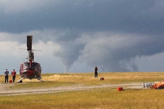
FORT FRANCES — A tornado watch is in effect from the Manitoba border to east of Shabaqua and north to Dryden and Fort Frances, as of Friday afternoon.
According to Environment Canada, the watch indicates the possibility of severe thunderstorms developing, which may produce tornadoes.
Wind gusts of up to 110 kilometres per hour, toonie-sized to ping pong ball-sized hail and heavy rainfall that could exceed 50 millimetres per hour are also possible.
The warning follows a second round of storms entering the region, which are expected to continue into the evening and have a total rainfall amount approaching 100 millimetres.
Emergency Management Ontario recommended that people take cover immediately if threatening weather approaches.
“Highway 11 from let’s say Kakabeka Falls to Fort Frances — that’s really where we’re worried about for a tornado threat (Friday) evening,” said Crawford Luke, a meteorologist with Environment Canada.
“Again, it’s not to say that we couldn’t see a couple of tornadoes in other areas as well.”
Environment Canada updated a thunderstorm watch issued earlier in the morning to report that a lower tornado risk was also possible for the Thunder Bay area.
Luke said their main concern, especially west of Thunder Bay, is anyone who might be camping or in the backcountry, like Quetico Park.
“Anyone that’s out in these kind of areas (it is) just really a good day to take the weather seriously, be aware of watches and warnings, have a plan of what you might do if you do encounter a storm,” said Luke.
In the event of a tornado or if a tornado warning is issued in the area, the national weather agency advised the public to go indoors to a room on the lowest floor, away from outside walls and windows. These rooms could include a basement, bathroom, stairwell or interior closet.
Residents were also warned to leave mobile homes, vehicles, tents, trailers and other temporary or freestanding shelters to move to a sturdy building if possible.
As a last resort, residents are recommended to lie in a low spot and protect their heads from flying debris.
