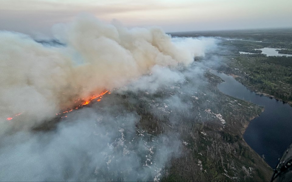
WABASEEMOONG — A large wildfire that’s over 31,000 hectares in size is still not under control, but has gotten no closer to an evacuated First Nation as of Monday afternoon, according to provincial wildfire officials.
Part of the eastern flank of the large fire, dubbed Kenora 20 by the Ministry of Natural Resources, remains about two kilometres from Wabaseemoong First Nation, according to Alison Bezubiak, a fire information officer with the MNR’s Aviation, Forest Fire and Emergency Services, and who is currently assigned to a pair of Kenora-area forest fires.
“Low-intensity fire behaviour has been observed over the past several days, and there's been no significant growth identified on the eastern flank of the fire,” Bezubiak said.
“The most activity in recent days has been observed on the western flank, west of the Manitoba border.”
Smoke from the fires, plus southeasterly winds, prompted Environment Canada to issue an air quality warning for a section southeastern Manitoba but, as of Monday afternoon, nothing was in effect for Northwestern Ontario.
Firefighters from Ontario and British Columbia, along with 15 helicopters and multiple levels of support staff have been assigned to the fire, as well as another one north of Wabaseemoong (identified as Kenora fire 14 by the MNR), Bezubiak said.
The ministry continues to do infrared scanning on the fires at night “to identify priority areas and where to best allocate those firefighting resources,” she added.
Wabaseemoong remains under an evacuation order, Bezubiak said, and the MNR has deployed sprinkler systems to guard all the structures throughout the community. Helicopters dropping buckets of water are being used on hotspots closest to the First Nation, she said.
“There has been no growth or change in perimeter on that section of the fire for several days,” she said.
The fire hazard remains extreme throughout the Kenora and Red Lake fire management areas, Bezubiak said and a restricted fire zone remains in effect for a large swath of the Northwest roughly from Quetico Provincial Park west to the Manitoba border.
“That means that no open air burning, including campfires, is permitted within the boundaries of the restricted fire zone,” Bezubiak said.
“Portable gas or propane stoves may be used for cooking and warmth, but they must be handled with extreme caution.”
