The Water Level Committee of the International Rainy Lake – Lake of the Woods Watershed Board 2022 Post Flood Report has concluded that preventative measures such as opening up a dam earlier to mitigate flood damage across Rainy Lake – Lake of the Woods Watershed would not have had a significant impact.
“The one thing people asked us a lot was what would have happened, or would the flood have been prevented, the property damage have been prevented, if the lake has been drawn down further in the spring,” said Megan Garner, chair of the Water Level Committee. “So, what we found when we ran the models is that it confirmed that would have made almost no impacted to the peak of the flood.”
The Water Level Committee used computer simulation modelling to complete the investigation comparing the standard rule curve from 2018 to the one employed in 2022.
"Tthe simulation found that the difference in peak level on Namakan Lake would have been one centimetre less than what was experienced, and the level would have returned below the All Gates Open level one day sooner," the report found. "As for Rainy Lake, the reduction in peak level would have been four centimetres and the level would have returned below the All Gates Open level two days sooner."
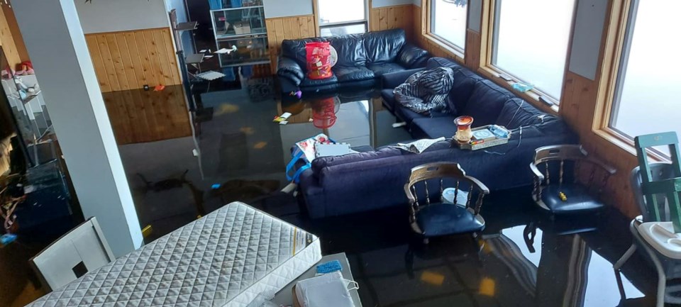
In 2022, the region experienced an above-level snowpack leading up to spring. As the snow melted, the ground became so saturated that it could not hold any more water.
“But it wasn’t the snowpack that caused the flooding. The flood was driven by a series of precipitation events that blew all historical records. We couldn't have forecast that amount of participation based on history. We didn’t know it was coming,” Garner said.
The Rainy River basin received 257 millimetres of rain in 2022, twice the recorded average.
Rainy Lake – Lake of the Woods watershed intake was recorded as the second-highest inflow water level between April and July.
Namakan Lake water levels rose to 342.18 metres which was the third highest on record since the record was set in 1916.
The water level of Rainy Lake rose to 339.31 metres, setting a new record 8 centimetres higher than the previous level record set in 1950, according to the report.
Garner said that the key message is that “a historic flood is a historic flood, no matter if it’s in nature or in a regulated system. What happened in 2022 would have been a flood in nature.”
Garner said there was nothing the WLC could have done to prevent the flooding.
Garner said while floods can't always be prevent, residents can focus on steps they can take to reduce the impact of flooding on their property.
“Thinking more on the lines of resiliency and what can be done for the next flood, which could happen this year, it could happen next year, we don’t know. They can be in a stronger position and not sustain much less damage,” said Garner..
The report makes several recommendations to the public and governing bodies which focus on changes to the low-risk and high-risk rule curves and more open communications to prepare the public for oncoming floods.
“One of the important things we heard from people is that they wanted to know more of what’s going on. They wanted to know what the WLC was doing in terms of regulation and what decisions we were making on an ongoing basis,” said Garner.
Garner states that in previous years, March would act as a firm deadline for whether or not a high-risk rule curve would be implemented in regulating the inflow of water into the Rainy Lake basin. This decision would guide dam operations throughout the spring.
Although the extremely high-water levels of Rainy Lake could not prevent the flood from happening in 2022, the WLC is implementing a spring regulation plan which involves more active decision-making and communication with the public over the course of this spring.
“Now we [have] a wider rule curve band in the spring we can target without having to make a decision,” said Garner.
This would mean that decisions to regulate dam spillways can be made frequently as weather conditions evolve throughout the spring, without having to declare a high or low flood risk.
Garner called he main takeaway from the report the need for transparency.
Garner said the public will be able to see that “the WLC is actively watching and monitoring what’s happening in the basin.”
“Communicating better to the public, essentially. It’s not just one plan we make in March and walk away and don’t look at it again,” said Garner.
The WLC is committing to providing more information to the public through its website, including a Pre-Spring Engagement Webinar, a series of videos that explain the hydraulic limitations at the outlet of Rainy Lake, and real-time and historical water level data.
Garner notes that this information has been widely available for several years; however, the WLC will be adding additional public information sessions as the spring gets into full swing.
Garner encourages the public to review the full report by clicking the link.
